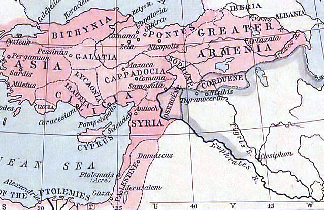
«Map showing kingdoms of Corduene and Adiabene in the last centuries BC. The blue line shows the expedition and then retreat of the ten thousand through Corduene in 401 BC.» https://en.wikipedia.org/wiki/Corduene#/media/File:Asia_minor_p20.jpg

«60 BC Kingdom of Corduene» https://en.wikipedia.org/wiki/Corduene#/media/File:Near_East_ancient_map.jpg

https://en.wikipedia.org/wiki/History_of_the_Kurds#/media/File:Corduene_sophene_commagene_osrhoene.png
The Ayyubid dynasty: «The most flourishing period of Kurdish power was probably during the 12th century, when the great Saladin, who belonged to the Rawendi branch of the Hadabani (or Adiabene) tribe, founded the Ayyubite (1171–1250) dynasty of Syria, and Kurdish chieftainships were established, not only to the west of the Kurdistan mountains in Syria, but as far away as Egypt and Yemen.» https://en.wikipedia.org/wiki/History_of_the_Kurds
 https://books.google.pt/books?id=Qi2TgAAazZwC&pg=PA36&lpg=PA36&dq=women+of+the+Ayyubid+family&source=bl&ots=UIHFLRmB_H&sig=UqKjDWBbM_J55mhMJfcY4ciTxy0&hl=pt-PT&sa=X&ved=0ahUKEwjnt7Pf2ozKAhXEhhoKHSOqAM0Q6AEIOTAE#v=onepage&q=women%20of%20the%20Ayyubid%20family&f=false
Shajar al-Durr - Ayyubid Empire - 1250 a.C.. Shajar al-Durr «was mother of the Ayyubid Sultan's only son. In 1249, French King Louis IX launched the 7th Crusade and the Sultan was killed in battle. Shajar al-Durr kept this a secret and ruled the empire in his name, during which she repelled the European assault and thus ended the 7th Crusade. Shortly after, she was elected Sultana of the empire in her own right.» Women of the Ayyubid family took a prominent role in the patronage of new constructions.

Selahedînê Eyûbî founded Ayyubid Empire
https://en.wikipedia.org/wiki/Ayyubid_dynasty#/media/File:Ayyubid_Sultanate_1193_AD.jpg
«In the second half of the 10th century there were five Kurdish principalities: in the North the Shaddadid (951–1174) (in parts of Armenia and Arran) and Rawadid (955–1221) in Tabriz and Maragheh, in the East the Hasanwayhids (959–1015), the Annazid (990–1117) (in Kermanshah, Dinawar and Khanaqin) and in the West the Marwanid (990–1096) of Diyarbakır.» https://en.wikipedia.org/wiki/History_of_the_Kurds


Hisn al Akrad, «Castle of the Kurds» https://en.wikipedia.org/wiki/Krak_des_Chevaliers#/media/File:Krak_des_Chevaliers_01.jpg
https://ro.wikipedia.org/wiki/Crac_des_Chevaliers#/media/File:Il_Krak_dei_Cavalieri.jpg


«Sit tibi copia, sit sapientia, formaque detur ; Inquinat omnia sola superbia, si comitetur.
Translation: Grace, wisdom and beauty you may enjoy, but beware pride which alone can tarnish all the rest.» https://en.wikipedia.org/wiki/Krak_des_Chevaliers#/media/File:Krak_des_chevaliers_inscription_latine.jpg https://en.wikipedia.org/wiki/Krak_des_Chevaliers#/media/File:Krak_des_chavaliers_plaine.jpg
Settlement of Kurds in XI Century (1030-1099 a.C.), the Castle was rebuilt in XII Century by Hospitaliers after 1142 d.C., until that year controled by County of Tripoli.


https://fr.wikipedia.org/wiki/Krak_des_Chevaliers#/media/File:La_plaine_d%27El_Bukeia_vue_du_Krak_des_chevaliers_en_1970.jpg
https://upload.wikimedia.org/wikipedia/commons/thumb/f/fc/HPIM3108.JPG/800px-HPIM3108.JPG
https://upload.wikimedia.org/wikipedia/commons/thumb/5/5e/Krak_des_Chevaliers_11.jpg/800px-Krak_des_Chevaliers_11.jpg
https://upload.wikimedia.org/wikipedia/commons/thumb/8/8f/Krak_des_Chevaliers%2C_Wassergraben.JPG/800px-Krak_des_Chevaliers%2C_Wassergraben.JPG
https://fr.wikipedia.org/wiki/Krak_des_Chevaliers#/media/File:Krak_des_Chevaliers_09.jpg
https://pt.wikipedia.org/wiki/Krak_des_Chevaliers#/media/File:Krak_westliche_Ringmauern.jpg
https://en.wikipedia.org/wiki/Krak_des_Chevaliers#/media/File:Chapel_of_Krak_des_Chevaliers_05.jpg
https://en.wikipedia.org/wiki/Krak_des_Chevaliers#/media/File:Hall_of_the_Knights_-_Krak_des_Chevaliers.jpg
https://en.wikipedia.org/wiki/Krak_des_Chevaliers#/media/File:Chapel_of_Krak_des_Chevaliers_01.jpg
https://en.wikipedia.org/wiki/Krak_des_Chevaliers#/media/File:Krak_des_Chevaliers_22.jpg
https://en.wikipedia.org/wiki/Krak_des_Chevaliers#/media/File:Chapel_of_Krak_des_Chevaliers_04.jpg

Hims Gap - NASA https://en.wikipedia.org/wiki/Homs_Gap#/media/File:Hims_Gap_sat.jpg

https://en.wikipedia.org/wiki/Orontes_River#/media/File:Map_of_the_Orontes_river.png

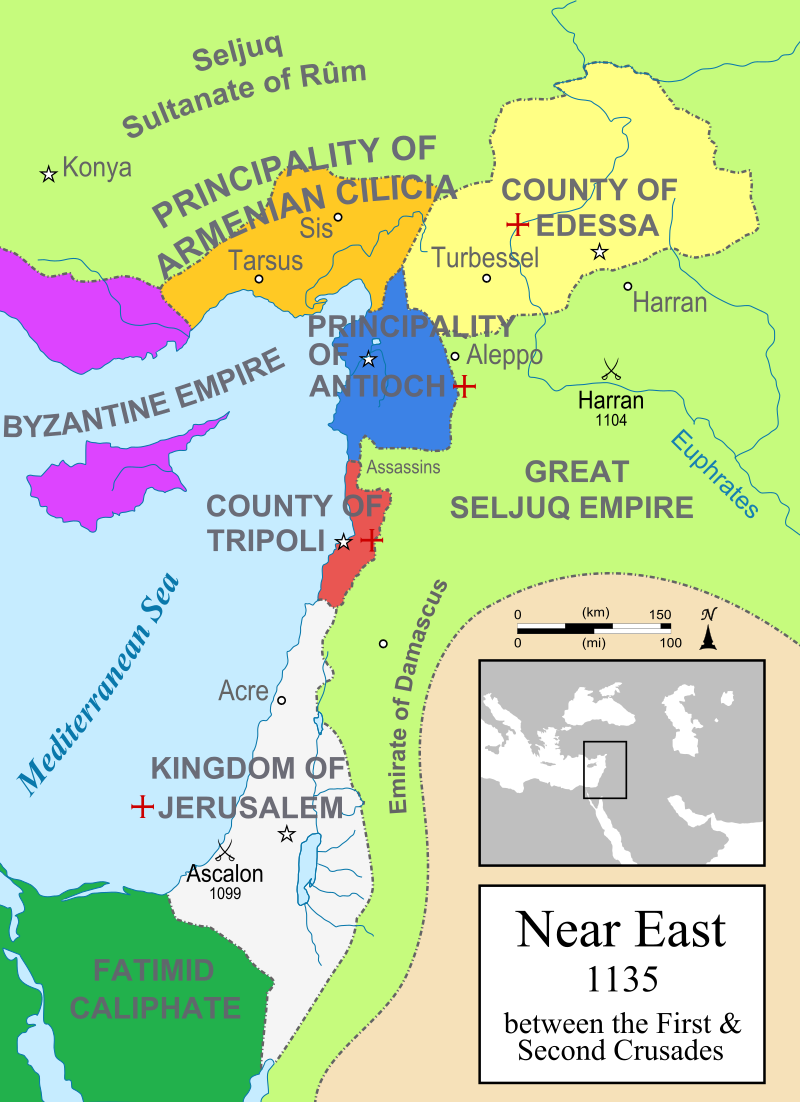
https://en.wikipedia.org/wiki/Krak_des_Chevaliers#/media/File:Map_Crusader_states_1135-en.svg

https://en.wikipedia.org/wiki/Krak_des_Chevaliers#/media/File:Map_Crusader_states_1190-en.svg

https://en.wikipedia.org/wiki/History_of_the_Kurds#/media/File:Kurdish_states_1835.png

https://en.wikipedia.org/wiki/Rojava#/media/File:Ethnicturkey1911.jpg

https://en.wikipedia.org/wiki/Turkish_Kurdistan#/media/File:Kurdistan1920.png

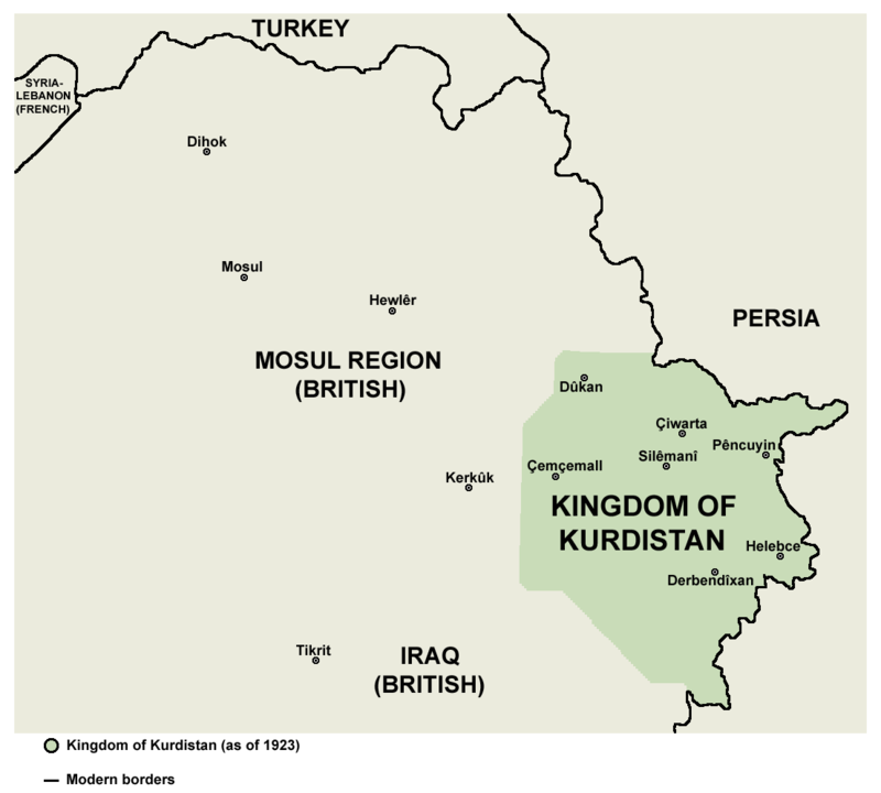
«Kingdom of Kurdistan in 1923» https://en.wikipedia.org/wiki/Iraqi_Kurdistan#/media/File:Kingdom_of_Kurdistan_%281923%29.png

Red Kurdistan https://en.wikipedia.org/wiki/Kurdistansky_Uyezd#/media/File:Red_kurdistan_1930.png

«Kurdish-inhabited areas in 1992 according to the CIA» https://en.wikipedia.org/wiki/Rojava#/media/File:Kurdish-inhabited_area_by_CIA_%281992%29.jpg


«Cappadocia (Kurdish: Kapadozîa,Qaba Dizya,Qapadozia or Kapadozia= Secret place) is a Kurdish historical region in Central Anatolia, largely in Nevşehir (Kurdish: "New Sher" The New city) Province. In the time of Herodotus, the Cappadocians were reported as occupying the whole region from Mount Taurus to the vicinity of the Euxine (Black Sea). Cappadocia, in this sense, was bounded in the south by the chain of the Taurus Mountains that separate it from Cilicia, to the east by the upper Euphrates and the Kurdish Highland, to the north by Pontus, and to the west by Lycaonia and eastern Galatia.» http://zagros-mesopotamia-anatolia-kurds.blogspot.pt/2012/08/cappadocia-kurdish-kapadoziaqaba.html
southeastern Turkey (Northern Kurdistan)
Kurds in Diyarbakir
http://static01.nyt.com/images/2011/01/10/world/TURKEY_span/TURKEY-articleLarge.jpg
northern Syria (Western Kurdistan)

https://en.wikipedia.org/wiki/Koban%C3%AE_Canton#/media/File:Rojava_february2014_2.png

western Iran (Eastern Kurdistan)

https://en.wikipedia.org/wiki/Kurdistan_Province#/media/File:Kurdistan_province.png

«A view of Sanandaj, the second-largest city in Iranian Kurdistan»
 Flag of Kurdistan
Iraqi Kurdistan (Southern Kurdistan)

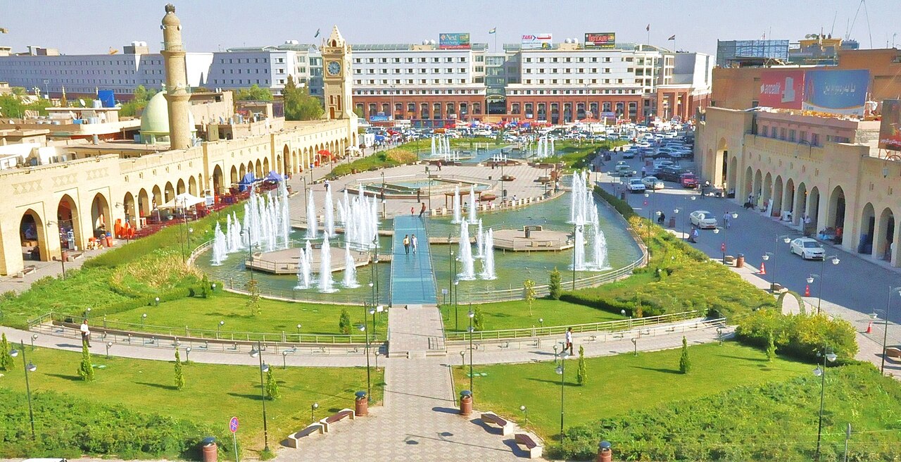
«Erbil, capital of Iraqi Kurdistan» https://en.wikipedia.org/wiki/Iraqi_Kurdistan#/media/File:Hewler-Kurdistan.jpg

«Greater Zab River near Erbil Kurdistan» https://en.wikipedia.org/wiki/Iraqi_Kurdistan#/media/File:Greater_Zab_River_near_Erbil_Iraqi_Kurdistan.jpg

«A canyon near the northern city of Rawandiz» https://en.wikipedia.org/wiki/Iraqi_Kurdistan#/media/File:Canyon,_north_eastern_Kurdistan.jpg

«Agriculture» https://en.wikipedia.org/wiki/Iraqi_Kurdistan#/media/File:Iraqi_Kurdish_villagers_in_field_near_Turkish_border.jpg
Turkish tyranny must stop against Kurdish Persons! http://www.thetimes.co.uk/tto/multimedia/archive/00947/NIP000179549657_947494c.jpg
http://static01.nyt.com/images/2011/06/05/arts/ABROAD-Jp-1/ABROAD-Jp-1-articleLarge.jpg
Sem comentários:
Enviar um comentário
Muito obrigado pelo seu comentário! Tibi gratiās maximās agō enim commentarium! Thank you very much for your comment!